French

Protected Areas and Community Rights: Using Local Maps to Support Sustainable Conservation in the Congo Basin
The best conservation projects start with people. Yet protected areas in the Congo Basin continue to be established and managed with poor consideration for local communities’ land and resource rights, fostering conflicts and human rights abuses. A lot of these toxic situations could be avoided if thorough participatory community mapping data, such as collected through MappingForRights, … Read more
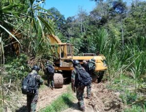
ForestLink app helps catch illegal miners red-handed in Peru
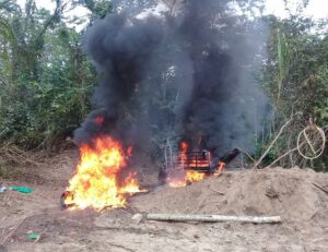
Environmental police seized an estimated £1 million of illegal mining equipment during a raid near Barranco Chico, in Madre de Dios | Photo credit: FENAMAD Over the last two months, dozens of suspected illegal gold miners causing terrible environmental damage in the Peruvian Amazon were caught with the help of the ForestLink smartphone app developed by the Rainforest … Read more

Cameroon communities speak out about impacts of large rubber plantation
Representatives of 21 villages affected by industrial rubber project Sud-Cameroun Hevea (“Sudcam”), which is responsible for the largest single destruction of rainforests anywhere in Central Africa, have denounced the impacts of the rubber plantations on their rights and livelihoods. In a statement issued last week, they ask the Cameroonian government and the company that their rights are … Read more
La cartographie communautaire peut permettre de contrer une des plus grandes menaces pesant sur le bassin du Congo
La planification participative de l’utilisation des terres, illustrée ici, peut aider les gouvernements à prendre des décisions éclairées concernant le régime foncier et la gestion des ressources naturelles. Les forêts tropicales de la République démocratique du Congo (RDC) sont parmi les plus intactes de la planète, avec des taux de déforestation beaucoup moins élevés qu’en … Read more
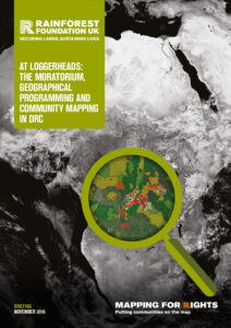
At Loggerheads: The Moratorium, Geographical Programming And Community Mapping In DRC
Of the three legal conditions attached to lifting DR Congo’s moratorium on new logging concessions, arguably only the third condition (on “geographic programming of future allocations”) remains to be fulfilled. Drawing on mapping data collected through MappingForRights and other sources, this briefing shows that any process which does not sufficiently take into account communities and … Read more
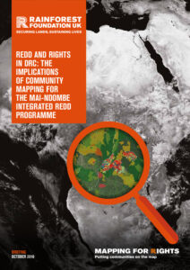
REDD and Rights in DRC: How Participatory Maps Can Inform the Mai-Ndombe Integrated REDD Programme
Forest tenure and resource mapping by local communities in Mai Ndombe is providing a highly detailed and comprehensive picture of customary claims and usages that are likely to extend across the entire province. The results, which authorised users can view on MappingForRights, have major implications for DRC’s flagship jurisdictional REDD+ programme, especially in terms of … Read more
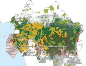
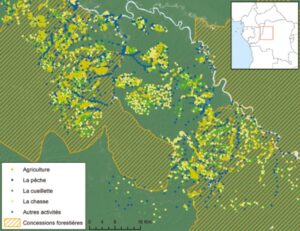
How community mapping can inform better policy decisions in the Congo Basin
Map showing overlap between customary rights and formal land allocations in Mai Ndombe province, DRC | Source: MappingForRights, WRI How do you decide the location and boundaries for a new nature reserve? How will new palm oil plantations impact nearby forest dwellers? How can local forest communities best secure their land and improve their livelihoods … Read more
Mapping For Rights: Putting Rainforest Communities on the Map
Since its launch in 2011, MappingForRights has supported more than a thousand communities to map and share highly detailed geographical information about their lands and resources so that decisions on forests do not neglect those who depend on them most. In this introductory briefing, we address the root causes land-based conflict in Central African forests, … Read more
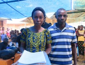
Historic first as communities in Democratic Republic of Congo gain legal rights over their local forests
Community members of Bosende, in Equateur Province, celebrate the news this week that their community forest application has been approved. | Photo credit: GASHE The Rainforest Foundation UK (RFUK) is celebrating, as a group of local communities in the Democratic Republic of Congo (DRC) is being granted legal rights to protect their local rainforests. In what … Read more
Real-time technology helps stop illegal mining operation in the Peruvian Amazon
A map of the affected area in Madre de Dios region. An indigenous community in the Peruvian Amazon helped to catch illegal gold miners red-handed this month using a smartphone app developed by the Rainforest Foundation UK (RFUK), leading to the dramatic destruction of illegal mining equipment. The Masenawa community in Peru’s Madre de Dios … Read more